Work has progressed to add the functionality for ICAO Basic ILS surfaces and this development included lots of new classes for the SDK.
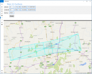
Here is a screen shot of a completed basic ILS surface drawn using Microsoft Bing maps, only a few parameters are needed to calculate the points that define the polygons you see coloured in cyan.
For the API, a new map element was added and this is a GeoPolygon. This can be made up of 3 or more points and it can have a fill colour along with an transparency value.
Support was added for different types of map projections and offering a choice in the type of map elements returned, in this case it could be 3D polygons or a set of 2D polylines.
SDK Usage
An example in calling the API that will return a collection of map elements to be drawn on your chosen graphics engine.
BasicIlsSurfaces basicIlsSurface = new BasicIlsSurfaces
{
    BasePoint = new GeoCoordinate(LatitudeCardinalDirection.N, 0, 0, 0, LongitudeCardinalDirection.E, 0, 0, 0),
    DirectionOfFlight = new CompassBearing(90),
    HeightMSL = heightMSL
};
GeoMapElementCollection geoMapElementCollection = basicIlsSurface.CreateGeographicalGeometry(CoordinateSystems.FindByMapProjection(MapProjections.UTM_WGS84), GraphicalRespresentation.PolygonLines3D);
API Documentation : BasicIlsSurfaces Class


