API: TERPS Standard Formulas for Geodetic Calculations (8260.58)

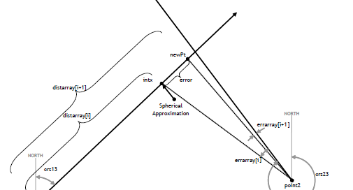
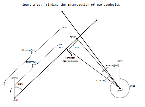
The following FAA standard formulas with test cases passing have recently been implemented with more to follow. Click on the link to open the FPAssistant SDK documentation. WGS84CrsIntersect - Computes the coordinates where two geodesic curves intersect WGS84Destination - Computes destination point based on course and a static point WGS84Distance - Distance between two points [...]

2022-08-28T00:55:00+00:00August 28th, 2022|FPAssistant SDK/API News|

UK Obstacle Data – QGIS and SQL Azure

A support question arrived asking about adding data into a spatial database, as it happens a article was written a while back on LinkedIn. In short, the GeoMapElements (Point, Circle, Line, Polygon, LineString, etc) are easily added to a spatial database using the method AsGeography(). The article describes how data contained in a Excel spreadsheet [...]

2022-05-22T15:08:23+00:00May 22nd, 2022|FPAssistant SDK/API News, General News|

API: FAA Geodetic Calcs for TERPS API added to SDK

Geodetic Calculation Feature Improvement To expand on the existing geodetic capabilities of the FPAssistant Suite SDK and to comply with FAA Order 8260 the GeoCoordinate and GeoCoordinateBasic objects (Structs) now support geodetic calculations based on Appendix A. TERP Standard Formulas for Geodetic Solutions. As documented in the appendix, it states... >> Algorithms and methods are [...]

2019-10-07T14:45:50+00:00October 7th, 2019|FPAssistant SDK/API News, General News|